// NATURE NEWS — SPAZIO & SCIENZA
Stone and water governed early human settlement of the desert
Nature
(2026) Cite this article
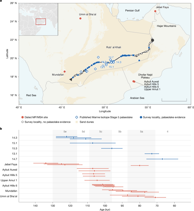
Models of early human dispersal rely on climate to predict where populations could settle, with freshwater assumed to govern the timing and geography1,2, particularly across the Saharo-Arabian arid belt, where humid windows episodically opened corridors into the desert interior3. Yet Pleistocene dispersals into ‘Green Arabia’ were brief and geographically constrained4,5, a pattern not explained by water availability alone. Here we show, from an approximately 1,500-km geoarchaeological survey through the Rub’ al Khali of Arabia, the largest sand sea in the world, that the availability of stone for tool manufacture operated as an independent factor on early human settlement. Palaeolake deposits were recorded at 55 of 125 localities investigated, yet no lithic artefacts and no knappable raw materials were found along the transect, with ground-surface visibility exceeding 95%, despite abundant freshwater and contemporary occupation at the desert margins. Spatial modelling of the Peninsula supports the inference that settlement tracked the co-occurrence of water and lithic raw materials rather than water alone. Across the Peninsula, 57% of water-accessible terrain lies on formations that lack knappable stone and adding raw-material availability raises discrimination of known site locations from an area under the curve of 0.695 to 0.768. Convergent patterns from Africa, North America and Asia indicate that the constraint is not peculiar to Arabia. Dispersal models that omit raw-material geology may systematically overestimate the habitable range of stone-tool-dependent populations.
Predictive models of early human dispersal across Arabia, built primarily on palaeohydrological reconstructions of palaeolake and palaeoriver networks and on climate-envelope reconstructions of precipitation and net primary productivity, identify interior basins as high-probability zones for Middle Palaeolithic (MP) and Middle Stone Age (MSA) occupation3,6, the broadly contemporaneous prepared-core industries of western Eurasia and Africa, respectively; because Arabian assemblages show affinities with both, the joint term MP/MSA is used throughout. The expectation that these palaeolakes attracted human settlement reflects decades of palaeoclimatic research demonstrating that orbital forcing periodically transformed the Arabian Peninsula into landscapes of lakes, wetlands and grasslands7,8,9. Geographical Information System (GIS)-based models built on this record have shown predictive success at the Rub’ al Khali margins, where dated MP/MSA assemblages occur alongside lacustrine deposits in the western basin10,11. Yet these models have never been verified against systematic ground survey in the desert interior, nor have they been evaluated against the distribution of knappable raw materials, a resource fundamental to Palaeolithic subsistence12 and consumed at rates that varied with the technology used13,14. Although it has been recognized that water would not be the sole determining factor in site location6, no study has evaluated this other variable.
The Rub’ al Khali occupies around 650,000 km2 of the southern Arabian Peninsula, bounded by the Asir and Yemen highlands to the west, the Dhofar Nejd and Hadhramaut plateaus to the south, the Hajar Mountains to the east and the Tuwaiq escarpment and Ad Dahna desert to the north. Its interior is dominated by longitudinal dune systems separated by interdunal corridors in which Quaternary sediments are exposed by deflation. During Pleistocene humid intervals, precession-driven intensification of the Indian Ocean monsoon raised regional water tables and formed lakes across the basin7,8,9,15, the most extensive of which are documented for Marine Isotope Stage 516. Archaeological evidence for these intervals is concentrated at the desert margins, where MP/MSA assemblages occur alongside dated lacustrine deposits at Mundafan10,11, Jebel Faya17,18, Umm a