// NATURE NEWS — SPAZIO & SCIENZA
Spatial and sectoral water demand assessment for the African continent
Nature
(2026) Cite this article
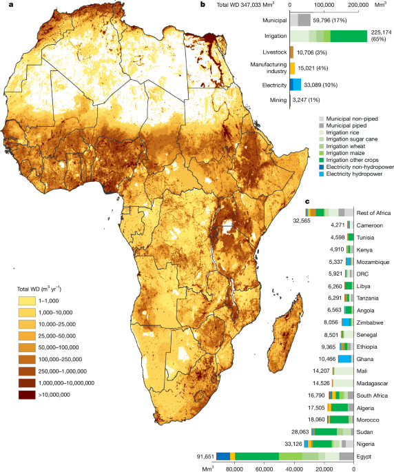
Water demand is the volume of water required by a sector to satisfy its needs1,2. Across Africa, these demands are frequently unmet3, yet their spatial and sectoral distribution remains incompletely characterized, limiting informed water-management decisions4. Here, we provide an Africa-wide estimate of water demand for 2020 across six sectors and multiple subsectors at high spatial resolution. Because the analysis integrates heterogeneous datasets and modelling assumptions, the resulting values should be interpreted as harmonized estimates rather than direct observations of realized water use. We estimate total annual water demand at 347 km3, comprising 60 km3 (17%) for municipalities (57–64 km3, with ±20% key parameters variations), 225 km3 (65%) for irrigation (214–233 km3, 95% confidence interval, with ±20% variations in irrigation efficiency), 11 km3 (3%) for livestock, 15 km3 (4%) for manufacturing, 33 km3 (10%) for electricity including hydropower and 3 km3 (1%) for mining (3–4 km3, with annual production variations). Estimated demand increased by 26% between 2010 and 2020. The dominant water-demand sector varies across regions and river basins, broadly reflecting established geographical and socioeconomic patterns. In parts of northern and southern Africa, estimated demand exceeds water availability, although results depend on assumptions regarding environmental-flow protection5. Elsewhere, water availability exceeds aggregate demand despite limited access to piped drinking water, indicating that physical availability alone does not determine water security. Our analysis therefore provides a spatially and sectorally resolved baseline for identifying water-demand pressures and access constraints rather than establishing a new causal mechanism of water insecurity. Local estimates should be interpreted cautiously given uncertainties in the underlying datasets.
Africa is a vast continent with heterogeneously spread water availability6,7. Yet, how sectoral water use and water demand (WD) are spatially distributed over the continent is not well known. Sectoral WD is the volume of water used by a sector to satisfy its needs, if sufficient water is available1,2,8. In many Western countries, sectoral water use generally equals WD; however, in African countries, this is often not the case. As an example, in 2020 only 47% of 1.36 billion Africans had piped drinking water access3, mainly because of a lack of adequate infrastructure. The WD of the remaining population that has no piped access is not accounted for in water use statistics of Aquastat9.
WD can be expressed in terms of water withdrawal (WW) or water consumption (WC)10. WW refers to the volume of water extracted from its source (rivers, lakes, aquifers). WC is the portion of WW that is not returned to the original water source after being withdrawn. Water use is a generic term that can mean both.
Sectoral water uses are difficult to quantify, making related data hard to find. The only way to accurately quantify real-world physical water uses is by measuring them, yet such data are only scarcely available.
A persistent lack of reliable water data and information is a widespread constraint on water management in the Global South4. For detailed water management assessments and informed policy decisions, knowing detailed WDs of all sectors in high spatial resolution is a necessity10. It is also important for researchers and stakeholders working in Africa to obtain open-access data, as they often lack the funds to purchase high-quality data. There is thus an urgent need for open-access, reliable, spatially distributed information on WDs covering Africa, including all relevant sectors. This limits research efforts and resulting science-based decisions among stakeholders.
To fill this data gap, we conducted an Africa-wide year 2020 WD analysis, at unprecedented spatial resolution (5 arcmin for 2 sectors, 2.5 ar